Black Canyon Two-Day: A Desert Water Plan That Works
The riding is straightforward: one long climb up, one long descent back. What makes this route serious is that there is exactly one reliable water source in 94 kilometres, and it is at the top.
- gravel 78%
- paved 14%
- doubletrack 8%
Season: October to April. Do not ride this in summer. Daytime highs in the lower canyon exceed 40°C from May through September and the water plan below does not survive that.
Where: Bradshaw Mountains, Arizona, United States
The Route Is Not The Problem
Ninety-four kilometres, one climb, one descent. Navigationally this is close to trivial, and if it were in Oregon it would be an easy weekend.
It is in the Sonoran Desert, and what makes it serious is a single number: one reliable water source in 94 km, at kilometre 47, at the top of a 1,700 m climb. Every decision on this route is downstream of that.
That single constraint is what turns an easy weekend into a route that punishes a thin plan.
The Water Plan, In Full
Leave Black Canyon City with five litres. Two bottles, a 2 L bladder in the frame bag, and a 1.5 L bottle in a cargo cage, or whatever arrangement gets you to five without hanging weight off the back.
The Agua Fria crossing at km 9 sometimes runs. After a wet winter it is a genuine source and you can filter and top up. By March it is often dry sand. Ride the route as though it does not exist and enjoy it if it does.
Bumble Bee at km 21 is a name on a map. There is no water there you should count on.
From km 21 to km 47 you are climbing continuously in the sun with nothing. This is where the five litres goes. In cool weather you should reach Crown King with about a litre in hand, which is the margin to aim for and not a drop less.
[[related:how-much-water-should-you-carry-bikepacking]]
Day One: Up
The lower canyon leaves town on pavement and turns to graded gravel quickly. The first 30 km climb steadily through saguaro and chaparral with essentially no shade, which is the reason the season window on this route is what it is.
Above Bumble Bee the road steepens and the surface deteriorates. Embedded rock, loose steep pitches and enough washboard that a loaded drop-bar bike stops being the ideal tool. It is rideable on 45 mm tyres and it is more pleasant on something bigger.
The transition is the thing people remember. You start in desert at 600 m and finish in ponderosa pine at 1,768 m, and the temperature drops roughly a degree every 150 m you climb. Arriving sweating and being cold within twenty minutes of stopping is the standard experience.
Crown King has a small general store with limited hours, particularly off season. Fill everything you own. Camp on Prescott National Forest land above town.
The Night
It gets genuinely cold up there. A 25 degree difference between the canyon floor at midday and the pines at 5 am is normal, and riders who packed for the desert they started in have a bad night.
A 0°C bag is the right call in every month this route is rideable. It is heavier than the latitude suggests and the elevation is what decides it.
[[related:cold-feet-emergency-sleep-system-boost]]
Day Two: Down
The descent is the payment for day one and it is a good one. Forty-seven kilometres, most of it gravity, on a surface that rewards a bike you trust.
Take the upper section carefully. The same embedded rock that made the climb slow makes the descent genuinely technical, and you are doing it loaded and probably tired. There is a bailout point around km 73 where passing traffic is still plausible. Below that, you are committed to the run out.
Water-wise the descent is cheap, rarely more than a litre and a half back to Black Canyon City, which is why the whole plan is built around the climb.
Before You Go
Both water sources below Crown King are seasonal and neither should appear in your plan as a dependency. Store hours at the top are short and unreliable off season.
Check current conditions, carry the full five litres regardless of what the last trip report said, and do not ride this route between May and September. The desert does not grade on effort.
Resupply and water
Checked against current conditions on August 3, 2026 . Seasonal sources and small-town opening hours change between years. Verify before you rely on any of them.
| km | Stop | Type | Notes |
|---|---|---|---|
| 0 | Black Canyon City | Water + food | Full services and the start. Leave here with five litres minimum in cool weather. This is not a suggestion. |
| 9 | Agua Fria River crossing | Water | Seasonal and unreliable. Runs after winter rain and can be bone dry by March. Treat any water here as a bonus and never as a plan. |
| 21 | Bumble Bee | Bailout | Historic townsite, essentially nothing there. No services and no dependable water. It is a landmark and a place to turn around, not a resupply. |
| 47 | Crown King | Water + food | The only reliable water and food on the route, at 1,768 m. Small general store with limited off-season hours. Everything about the two-day plan is built around arriving here. |
| 52 | Crown King area dispersed camping | Water | Prescott National Forest land above town. Pine forest, genuinely cold at night, and 25 degrees cooler than where you started. |
| 73 | Upper Crown King Road | Bailout | Descending, this is the last point with any realistic chance of passing traffic. Below here you are committed to the run out. |
Kit for this route
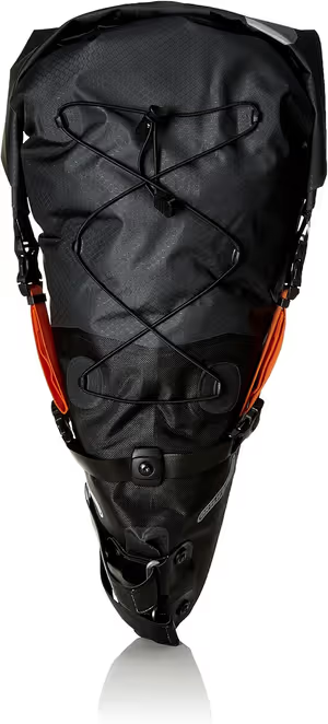
Ortlieb Seat Pack L
- • Absolute waterproof reliability
- • Exceptional anti-sway stability
- • Integrated air compression valve

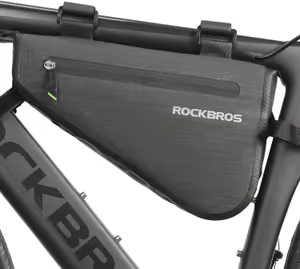
- • Stiff internal plates
- • 2.5L of structured capacity
- • 11 Mounting hole options
- • Incredible value for money (RDS down)
- • True 0°C comfort rating (ISO tested)
- • Durable 20D fabric resists abrasion
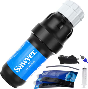
- • Exceptional flow rate
- • Extremely lightweight
- • Versatile mounting

- • Legendary reliability
- • Consistent flame control
- • Includes hard carry case
Frequently Asked Questions
How much water do I actually need?
Is Crown King Road rideable on a gravel bike?
What happens if the store at Crown King is closed?
Can this be done in one day?
Mark Davis
Mark is accustomed to carrying his body weight in water across the Southwest. Meticulous about load distribution, if a piece of gear rattles or rubs, Mark will find a way to fix it with a Voile strap and some duct tape.