Three Days in the Oregon Coast Range
Sixty-four percent gravel, most of it logging road, and a genuine chance of rain in any month. If your bags are going to leak, they will leak here, which is exactly what makes it worth riding.
- gravel 64%
- paved 27%
- railtrail 9%
Season: June to early October. Outside that window the logging roads are rideable but the rain is relentless and the daylight runs out at 4 pm.
Where: Oregon Coast Range, United States
The Argument For Riding Somewhere Wet
Most route reports are written about places that look good in photographs. This one is written about a forest that is grey nine months a year and where the main scenic feature is a clearcut.
The reason to ride it is that the Coast Range is a genuinely serious gravel network within an hour of Portland, with more logging road than you could ride in a season and reliable water everywhere. The reason to ride it in the rain is that it is the most honest test of a bikepacking setup there is.
This site has written a lot about whether bags are waterproof. Two days here would settle the question faster than any amount of testing in a yard with a hose.
Day One: Banks to the Nehalem
The first 33 km are the Banks-Vernonia State Trail, which is paved rail trail and about as gentle a start as bikepacking offers. Use it to work out whether anything on the bike is going to rattle loose, because after Vernonia you will not want to be stopping.
Vernonia at km 33 is the last town on the loop. There is a grocery and a cafe and you should treat this as the point where you commit, because from here the route turns onto forest roads and the next reliable services are back in Banks two days later.
The climb out of the Nehalem valley starts almost immediately and it sets the pattern for the whole trip: short, steep, loose, repeated. Camp on day one is in the drainages north of Timber, on creek water, with the road noise entirely gone by dark.
Day Two: The Tillamook
This is the long day and the good one. The route works west and south through the Tillamook State Forest on a network of gravel roads that mostly do not appear on a road map.
Two things to know. Active harvest units close roads with little notice, so check current conditions and be ready to reroute rather than treating the line as fixed. And log trucks own these roads completely. They are wide, they are fast, they cannot stop, and the correct response to hearing one is to be off the road entirely before you can see it.
Water is everywhere. Creeks cross the road every few kilometres through most of the summer, and the practical filtering problem here is turbidity rather than scarcity. After rain, everything runs brown with logging silt, which clogs a squeeze filter fast. Let it settle in a bottle for ten minutes before you push it through anything.
Camp on day two is in the upper drainages. Eleven straight hours of rain is a realistic September night here, and it is the condition your waterproofing claims get settled in.
Day Three: Out Via Highway 6
The last day drops back east toward the Highway 6 corridor and returns to Banks through the lower Nehalem valley.
There is a bailout at km 124 where the route touches the main highway. If the weather has taken the fun out of it, turn east and you are back at the car in about 45 km of pavement. Nobody has ever regretted taking that option in a Coast Range September.
If the weather holds, stay on the gravel. The lower valley is the prettiest part of the loop and it is the one section where the climbing lets up enough to look at anything.
Before You Go
Forest road closures, harvest activity and fire restrictions all change through the season, and this route crosses working timberland rather than parkland.
Check current conditions with the state forest before you leave, carry the means to filter turbid water, and treat every water point listed here as something to verify rather than rely on. The Coast Range is generous with water right up until the one September when it is not.
Resupply and water
Checked against current conditions on August 3, 2026 . Seasonal sources and small-town opening hours change between years. Verify before you rely on any of them.
| km | Stop | Type | Notes |
|---|---|---|---|
| 0 | Banks | Water + food | Trailhead town at the south end of the Banks-Vernonia State Trail. Full resupply, and the last one until Vernonia. |
| 33 | Vernonia | Water + food | Grocery, cafe, water. This is the last real town on the loop and you are only a fifth of the way round. Carry two days of food from here. |
| 58 | Nehalem River crossings | Water | The river and its tributaries run all summer. Filter everything. Logging country means turbidity after rain and cattle upstream in places. |
| 71 | Timber | Bailout | Tiny settlement on the highway. No reliable services. It is a bailout to pavement and a phone signal, not a resupply. |
| 96 | Tillamook State Forest, upper drainages | Water | Creeks throughout. Abundant in June, thinner by late September. The forest is wet by reputation and it still pays to check before a dry camp. |
| 124 | Highway 6 corridor | Bailout | The route touches the main highway. From here you can turn east and be back in Banks on pavement in about 45 km if the weather has beaten you. |
| 154 | Lower Nehalem valley | Water | Reliable creek water and the last camping before the run back to Banks. |
Kit for this route
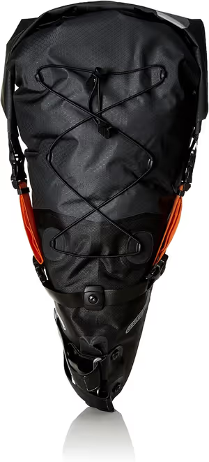
Ortlieb Seat Pack L
- • Absolute waterproof reliability
- • Exceptional anti-sway stability
- • Integrated air compression valve

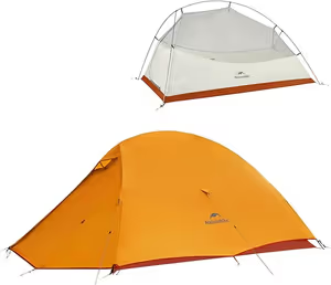
Naturehike Cloud-Up 2 Tent
- • Exceptional weight-to-price ratio
- • Packs very small
- • Quality aluminium poles

Therm-a-rest NeoAir XLite NXT
- • Incredible warmth-to-weight ratio (R-4.5)
- • Significantly quieter than previous model
- • Packs down to 1L water bottle size
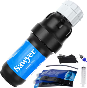
- • Exceptional flow rate
- • Extremely lightweight
- • Versatile mounting
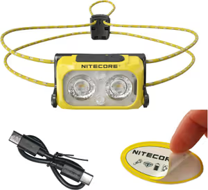
- • Incredibly light (45g)
- • USB-C charging
- • Independent red light
Frequently Asked Questions
How wet does it actually get?
Are the logging roads open to bikes?
Is 187 km over three days hard?
What tyres do I want?

Jake Wilson
Jake has spent the last 5 years pushing his bike through the muddiest backroads of the Pacific Northwest. He isn't a professional racer, but he knows exactly what gear breaks first and what actually lasts when you're 40 miles from the nearest town.